For decades, giving an address in Panama often meant describing landmarks instead of using an actual postal code. Directions like “across from the minisuper,” “after the church,” or “next to the mango tree” became part of daily life for residents, delivery drivers, and even emergency services.
That is now beginning to change.
On May 7, Panama officially launched its new National Geolocated Postal Code System, a major modernization project designed to standardize addresses nationwide and improve logistics, deliveries, mapping, and emergency response services.
The new platform, developed by Correos y Telégrafos de Panamá (COTEL) together with the National Institute of Statistics and Census (INEC), allows users to locate homes and businesses using exact geolocation data through the official portal:
https://www.codigospostalespanama.gob.pa
The initiative represents one of the most significant updates to Panama’s postal and address infrastructure in decades.
A Long-Overdue Modernization
Panama has historically operated without a fully integrated national postal code system similar to those used in countries such as the United States, Canada, or much of Europe. While some postal references existed, the country largely relied on descriptive directions that often caused confusion, delays, and failed deliveries.
According to COTEL Director Omar Torres, the project took approximately eight months to complete and was developed entirely with Panamanian talent alongside technical collaboration with Google focused on geolocation and mapping systems.
“This is an easy way to answer the question: ‘Where do I send it?’” Torres explained during the official launch.
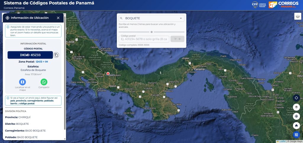
The system assigns each address an alphanumeric code tied to a precise geographic location. The letter within the code identifies the province, while the numbers correspond to routes, postal offices, and subzones that help narrow down exact locations.
How the System Works
Users can now enter the official postal code portal and search for their home, apartment, business, or property directly on the map.
Once the location is selected, the platform generates an eight-character geolocated postal code that can be used for:
- Online shopping deliveries
- Courier services
- Official correspondence
- Navigation and directions
- Emergency response coordination
During the launch presentation, attendees reportedly tested the system live from their mobile phones and successfully located their homes using the platform.
Authorities emphasized that the system is designed to function not only in Panama City but also in rural areas and indigenous comarcas, where address standardization has historically been even more difficult.
Why This Matters for Panama
The launch may sound simple on paper, but the implications are significant.
For years, Panama’s informal addressing system created friction in sectors ranging from e-commerce and logistics to banking and emergency response. International shipping companies and local couriers frequently struggled with incomplete or inconsistent directions, especially outside major urban centers.
The new postal system could help reduce:
- Lost packages
- Delivery delays
- Incorrect shipping destinations
- Operational inefficiencies
- Difficulties locating homes during emergencies
The timing is also notable as Panama continues seeing increased use of online shopping platforms, food delivery apps, digital services, and international shipping.
In practice, this could bring Panama closer to the logistical standards already common in more digitally integrated economies.
More Than Just Mail
INEC Director José Francisco García explained that the initiative is not intended to replace platforms like Google Maps or Waze, but rather to strengthen Panama’s own geographic data infrastructure.
“The idea is to have our own map of information,” García said.
Authorities also confirmed this is only the first phase of the project.
Future stages could integrate institutions such as:
- SINAPROC
- Transit authorities
- Government agencies
- Urban planning departments
Officials believe the system may eventually support road planning, mobility analysis, disaster response coordination, census data organization, and other national infrastructure projects.
That broader vision suggests the postal code rollout is not simply about mail delivery. It is part of a wider digital modernization effort aimed at improving how information and geographic data are managed across Panama.
A Cultural Shift as Much as a Technical One
The launch also reflects something culturally important for Panama.
The country has long been known for its informal, landmark-based way of giving directions. While often charming and uniquely Panamanian, that system became increasingly difficult to sustain in a modern economy driven by technology, logistics, and digital commerce.
The new postal code system signals a transition toward a more connected and standardized national infrastructure while still adapting to Panama’s unique geography and communities.
Whether the system reaches its full potential will likely depend on adoption, public awareness, and long-term institutional support. But after decades of improvised directions, Panama is finally taking a major step toward building a true nationwide postal and geolocation framework.
For more information about Panama communities and areas including Panama City and Boquete, visit Casa Solution’s Panama community guides.
If you’re considering relocating, investing, or simply learning more about life in Panama, Casa Solution Real Estate provides local insight and guidance across the country.
Article written: May 9, 2026